Fly Saint-Hilaire. Your base camp for a paragliding adventure in the French Alps.
The paragliding site at Saint-Hilaire is one of the most reliable flying spots in the French Alps. Three launches between 890m and 940m, a massive landing field at Lumbin, and a geography that shields the plateau from most bad weather systems. Whether you’re a beginner on your first flights or a seasoned XC pilot chasing distance, this paragliding site delivers.
Whether you’re here to sharpen your thermalling, nail those top landings, or push further along the classic XC routes, Saint-Hilaire is the kind of playground that keeps you coming back for more.
From smooth morning glass-offs to mellow evening restitutions, every flight here teaches you something — sometimes about the air, sometimes about yourself. All of it happens above stunning scenery, in good company, surrounded by a tight and passionate community of pilots who just can’t get enough of this place.
Why This Paragliding Site Stands Out

I’ll be upfront: I’m biased. But I’m pretty confident Saint-Hilaire is the site in the French Alps with the most flyable days in a year. If it’s not in first place, it’s definitely on the podium.
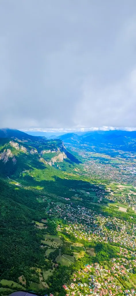
The geography does a lot of the heavy lifting, because Saint-Hilaire sits on a 1000-metre-high plateau on the foothills of the Chartreuse massif — an 80 km-long mountain range running north to south. It acts as a natural shield against low-pressure systems and strong westerlies. Across the valley, meanwhile, the Belledonne range covers our backs from most systems pushing in from the southeast.
The result? A site that flies when other spots in the region don’t.
With moderate northerly winds, Saint-Hilaire becomes a fantastic playground — whether you’re an aspiring thermal pilot or a seasoned XC adventurer chasing distance. When the northerlies pick up too much, the Combe de Savoie (Montlambert – Chamoux) is usually the call. But those days are the exception, not the rule.
When to come?
Spring — March to May
Spring is when things start to wake up. Thermal flying and big XC days can arrive as early as mid-March. As a result, the whole place slowly shifts from winter mode into full flying season. Energy on the plateau builds week by week.
Early Summer — June & July
Early summer is a well-oiled machine. It’s not unusual for schools to have their students in the air by 7 a.m., riding the gentle morning slope breeze before the thermals kick in.
By 11, however, the experienced pilots take over. They map out plans for local sessions, cliff-chasing above the plateau, or bold crossings toward Belledonne, the Bauges, or the Vercors.
Late Summer — August & September
August and September tend to bring more stable conditions — great for high-altitude thermalling clinics. And of course, the Coupe Icare lands in the third week of September. The festival transforms the site for a full week: costumes in the air, cinema screenings in the evenings, and a kind of joyful madness that’s hard to describe and impossible to forget.
Autumn — October
October is quietly one of the best months of the year. The summer crowds are gone, the light is extraordinary, and hike-and-fly season hits its peak. It gets a little less reliable toward the end of the month as the Azores high starts to loosen its grip — but the good days more than make up for it.
Winter — November to February
Paragliding Site Saint-Hilaire: The 3 Launches
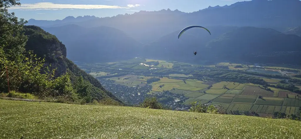
Saint-Hilaire has three official launch sites, all sitting between 890m and 940m altitude, with a vertical drop of around 650–700m to the landing. They share the same landing zone — the large field at Lumbin — but each has its own character.
North Launch — the carpet launch
This is the one you’ve probably seen in Coupe Icare footage: a wide, artificial-turf launch that’s smooth, spacious, and forgiving. It’s the easiest of the three and where most tandem and school flights depart from. Faces east to southwest. Altitude: 890m.
Best for: all levels, morning flying, tandems, school students.
Watch out for: thermic conditions building from late morning onward in spring and summer.
East Launch — the new one
Tucked along the Pal de Fer trail, the East launch is the newest of the three. It’s a good option when the North is crowded, and the first one you reach if you’re hiking up from the landing. Faces east to southeast. Altitude: 921m.
Best for: experienced pilots, hike-and-fly, less busy days.
Watch out for: gliders exiting the North launch — stay aware of traffic. Strong thermic exits from midday onward.
South Launch — the football field (yes it's that big)
The biggest of the three and the favourite of XC pilots. It has room for dozens of gliders and comes equipped with picnic tables and — critically — a toilet. The slope school area sits right behind it, which makes it a hub of activity on busy days. Faces east to southwest. Altitude: 940m.
Best for: XC pilots, Acro pilots, advanced flying, big days.
Watch out for: lee side turbulence in northerly conditions. Strong thermic activity from midday.
Getting to the launches
The funicular runs from the valley up to the plateau, arriving right next to the North and East launch. By car, follow signs to the funicular from Saint-Hilaire village. For the South launch, park at the village main car park near the tourist office and follow the path directly behind.
The Funicular
Built in 1920, it’s the oldest funicular still in operation in France. Its original purpose was to bring building materials up to the Saint-Hilaire plateau for the construction of a sanatorium. It was later repurposed in the 1960s into a teaching hospital complex, complete with a swimming pool, a high school, and even a cinema. However, the massive complex was declared an avalanche risk in the early 2010s and subsequently demolished, leaving almost no trace of its presence in the naturally preserved surroundings.
Unfortunately, the funicular rails and lower station suffered significant damage in recent storms. As a result, check the funicular website for the latest operational status before your visit.
The Lumbin to Saint-Hilaire Shuttle - Bus line 305
The shuttle between Lumbin landing and Saint-Hilaire takeoffs runs every day in July and August, and on weekends from April to June. It takes just 30 minutes and costs only €5 per trip — perfect for keeping the flying day rolling smoothly.
Getting to launch by car
From the north, take the A41 motorway and exit at junction 23 (Le Touvet). From Le Touvet, follow the D29 up toward the Plateau des Petites Roches and Saint-Hilaire-du-Touvet. Alternatively, you can come up via La Terrasse, following signs for Saint-Hilaire from there.
From the south, take the A41 and exit at junction 24.1 (Saint-Ismier). Follow the roundabouts toward Saint-Hilaire-du-Touvet. You’ll drive through Saint-Nazaire-les-Eymes, which has its own landing field at the foot of the Manival — a useful reference point if you’re planning XC flights along the southern Chartreuse ridgeline.
In both cases, the main car park is located next to the tourist office in Saint-Hilaire village, a short walk from all three launches.
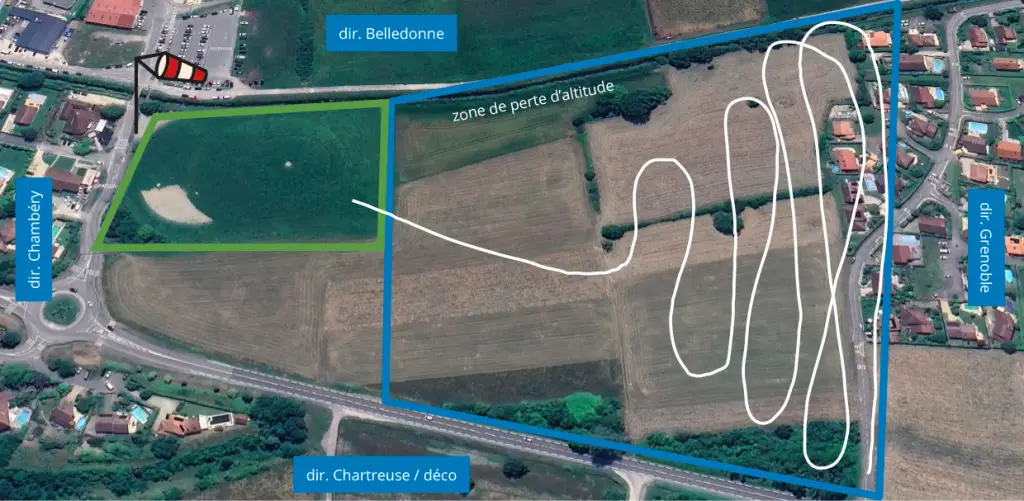
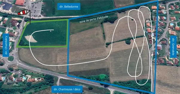
The Landing Zone — Lumbin
The landing field at Lumbin is one of the best in the Alps. Large, flat, open to all wind directions, and with a precision target for those who like that kind of thing. There’s a dedicated gear-folding area, a big car park right behind the field, and — right across the road — a shop, a snack bar, and a restaurant terrace where you can watch the parade of gliders coming in.
Getting there:
From Grenoble: Take the A41 to Crolles, then the D1090 toward Lumbin. At the village roundabout, turn right. Car park is directly behind the landing.
– From Chambéry: Take the A41 or D1090 to Le Touvet, continue to Lumbin. At the roundabout on the far side of the village, turn left.
– On Waze or Google Maps: search « Atterrissage parapente Lumbin »
Approach patterns
Northerlies
Southerlies
The landing is generally under the influence of the northerly valley breeze coming down from Chambéry — S-type or L-type approaches are most common.
If the wind in the valley is blowing from the south, it’s common to lose altitude on the south side of the landing field and make a U-type approach.
XC Flying from the Saint-Hilaire Paragliding Site
A few key tips for visiting XC pilots:
- Study the Chartreuse brise patterns before your first big day — the north valley wind from Chambéry is the defining factor
- Connecting with the higher Chartreuse ridgeline usually requires gliding south toward Grenoble first. The « Château Nardant » thermal will give you the height to push into the Chartreuse massif toward Bec Charvet — and from there, you’re just one thermal away from the mythical Dent de Crolles.
- For live conditions: check the numerous weather beacons on SpotAir and the site webcam before heading up
Hike & Fly at Saint-Hilaire
The Chartreuse is hike-and-fly country, and Saint-Hilaire is the perfect base for it — especially in autumn and winter when the crowds thin out and the mountain feels like it belongs to you again.
Pal de Fer — the classic warm-up
A straightforward ascent from the funicular car park, following the yellow-marked trail past the Oule waterfall and up to Saint-Hilaire village. Around 700m of elevation gain, about 1h15 on foot. Launches you straight onto the North or East launch. *(Note: check with the tourist office before heading up — the trail has been closed at times due to rockfall.)
Dent de Crolles — the statement flight
At 2062m, the Dent de Crolles dominates the plateau and is clearly visible from the landing at Lumbin. Flying from the summit is absolutely worth the effort. There are two main approach routes: via the Col du Coq (660m gain, 1h30) or from Saint-Hilaire itself (1100m gain, 2h). Both reach the same summit with north and south launch options. From there, you can land at Lumbin, Saint-Nazaire, or — if you nail the conditions — back at Saint-Hilaire.
⚠️ This is not a beginner outing. Indeed, the approach involves steep, exposed terrain and some sections of fixed rope near the summit. Moreover, it’s a serious mountain hike best suited to experienced hikers — and the flying itself demands the same level of respect. Therefore, if you’re new to hike-and-fly or unfamiliar with mountain flying environments, do this one with someone who knows the route and the conditions. The summit is no place to be figuring things out for the first time.
Reach Out Anytime
We’re here to answer your questions and help you plan your unforgettable paragliding experience. Don’t hesitate to contact us.
Email Us
Got questions? Drop us a line.