Cross Country Paragliding – Saint-Hilaire, French Alps
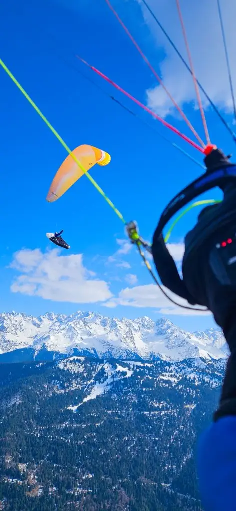
Cross country paragliding from Saint-Hilaire is some of the best XC flying in the French Alps. The site sits at the junction of four major massifs — Chartreuse, Belledonne, Vercors, Bauges — and on a good day, the question isn’t whether you can go somewhere. It’s how far. Pilots doing cross country paragliding here have flown triangles past Annecy, straight lines to the Mediterranean, and everything in between.
Cross Country Paragliding: the Classic Saint-Hilaire Route
The classic cross-country paragliding route from Saint-Hilaire follows the same spine: up the Chartreuse, across to Belledonne, and back. It’s a route that teaches you the site. It also scales with your level — a good intermediate pilot can fly 60–80 km on it. On the right day, it becomes a 150 km triangle.
The route starts with the Chartreuse ridge. From the North launch, the classic line heads south along the cliffs toward the Fort du Saint-Eynard — a solid early climb, well-exposed to the morning thermals. Grenoble spreads out below you. From there, the ridge continues south to the Rachais and the Bastille, the cable car fort that hangs above the city. This is technical flying. The ridge is narrow, the thermals punchy, and the valley below is Grenoble’s airspace. Know your limits before you get here.
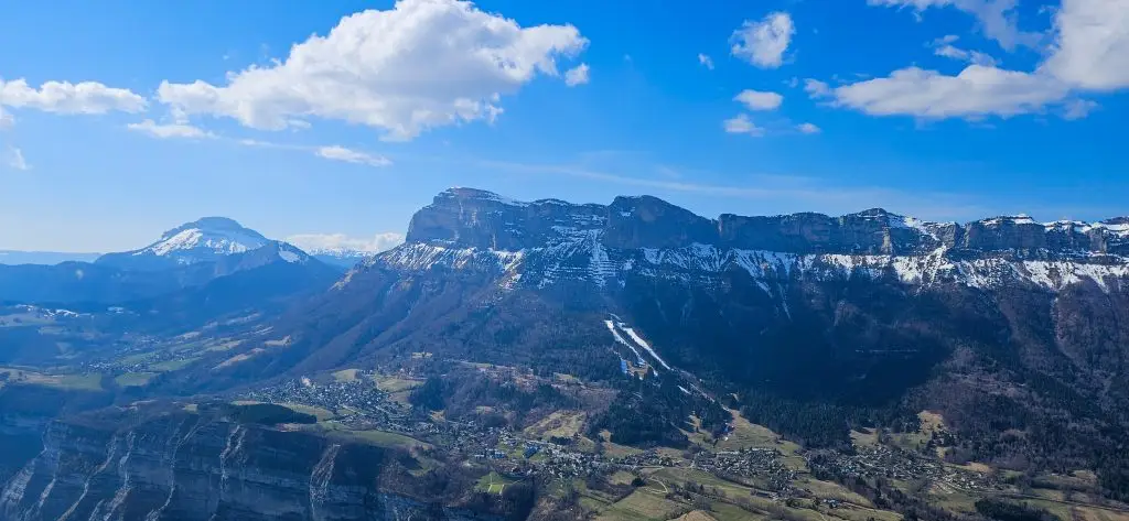
From the Chartreuse, the route turns north — back up the spine toward the Granier, the great limestone wall that marks the northern end of the massif. This is where the day opens up. Topped out above 2200m, you’re looking across the valley at Belledonne on one side and the Bauges on the other. Two completely different days are on offer from here.
The Belledonne crossing via Saint-Genis is the most direct eastward move — 10 km across the Grésivaudan valley. It requires a clean departure above 2200m from the Chartreuse side and a good read of the valley brise below. The key is the Saint-Genis, the first reliable trigger on Belledonne’s west face. If the connection goes well, you hop onto the Cret du Poulet. From there, the Belledonne ridge runs north-south for 40 km — a highway of thermals on a big day. It connects to the Lauzière and eventually the Beaufortain and Tarentaise beyond.

Going North: XC Paragliding to the Bauges & Beyond
The other door from the Granier opens north. It leads to some of the most rewarding flying in the region.
The transition to the Bauges via the Savoyarde is one of the most discussed moves in local XC flying. It’s 10 km across an open valley, with two competing brises. The Chambéry valley brise pushes south, while the interior Bauges brise pushes down from the north. They meet at the Savoyarde — which is exactly where you need to cross.
The key is trajectory, not altitude. Most pilots aim too far right, toward the Savoyarde rock itself, and get swept out over Montmélian with no recovery. The correct line goes further left, toward the Montgelas shoulder. There, the north-west face sits at wind and allows recovery even when you arrive very low. It’s turbulent, it’s humbling, and it’s one of the most satisfying moves in the Alps when it works.
Once on the Bauges, the ridge runs clean toward Annecy — Pic de la Sauge, Galoppaz, Colombier, Roc des Bœufs. It’s a logical chain that takes you to the lake in good conditions. Triangles of 130–150 km close here regularly. In the CFD rankings, a Triangle Saint-Hilaire / Annecy (147 km, 8h) and a Triangle Saint-Hilaire / Dent du Chat (137 km, 6h30) represent what a strong pilot can achieve on a generous spring or summer day.
The Bigger Picture
On exceptional days, Saint-Hilaire pilots go further south. Some head into the Vercors via the Moucherotte. Others push toward the Dévoluy and the Écrins, or follow the Belledonne chain all the way to Chamrousse and beyond. The club record from this area stands north of 300 km.
The tools to plan these routes are well-established. Use XCplanner for route simulation, the CFD for studying what others have actually flown from here, and Google Earth for visualising the terrain before you go.
If you want to fly with someone who knows these routes — and who can coach you through the transitions rather than just point at a map — get in touch. We can connect you with English-speaking instructors who fly this terrain every week.
Your First Cross Country Paragliding Flight from Saint-Hilaire
Saint-Hilaire is one of the best places in the French Alps for cross country paragliding — whether it’s your first XC or your hundredth. And not by accident.
The site is structured in a way that rewards progression. The lower cliffs provide reliable ridge soaring from early in the season. This lets you build airtime and read the conditions without committing to big terrain. Above them, the upper plateau opens access to the higher Chartreuse ridge — a natural second stage that makes transitions to other massifs possible. In practice, you can spend a week here and fly both levels depending on what the day gives you.
Prevol runs dedicated cross-country clinics throughout the season. The format is practical — you fly with a coach, you debrief what happened, and you go again. Progress is fast when the theory and the airtime happen in the same day.
The reliability of the site helps too. Saint-Hilaire has more flyable days per year than almost anywhere else in the French Alps. That means you’re not spending your clinic week on the ground waiting for a weather window. When you do fly, the geography does the teaching. The cliffs give you the height to experiment, the valley gives you the feedback, and the massifs on every horizon give you something to aim for.